

Science Pick
A collection of write-ups that speak for what's trending in science & technology.

Ad
IRNSS - India's Own GPS equivalent navigation system
For Many years, India has been dependent on the technologies developed by other countries. On the other side, India is the second largest producer of engineers in the world. Year after year, lot of developments happened in the technology sector.
IRNSS (Indian Regional Navigation Satellite System) is an outcome of one such developments in the country. India has taken a huge step in developing its own satellite navigation system and thus, need not be dependent on the GPS services from USA or Russian GLONASS. Sounds peculiar?
Yes, what you are thinking is right! India is all set to augment GPS navigation systems with IRNSS.
So, what’s IRNSS?
Well, during the Kargil war in 1999, India approached USA for the GPS data information to track the troops from Pakistan for which, USA denied upfront. That was when Indians realized that they need their own navigation system to map and track the humongous span of mass and land, where India spreads across the globe.
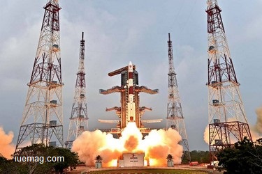
The project IRNSS got approved in May, 2006. India's plan is to have seven satellites that will provide navigational information over the country and up to 1,500 kilo Meters (932.06 miles) around the mainland. Its 5th satellite was launched on 20th January 2016 via Polar Satellite Launch Vehicle - C31 from Satish Dhawan Space Centre at Sriharikot.
IRNSS is an independent Navigation Satellite System providing services in the Indian Region which is being implemented by the Indian Space Research Organization (ISRO).The project is being managed by ISRO Satellite Centre of Bangalore with support from the other work centers SAC Ahmedabad, ISTRAC Bangalore, MCF Hassan and VSSC Thiruvananthapuram.
Well, during the Kargil war in 1999, India approached USA for the GPS data information to track the troops from Pakistan for which, USA denied upfront. That was when Indians realized that they need their own navigation system to map and track the humongous span of mass and land, where India spreads across the globe.
The project IRNSS got approved in May, 2006. India's plan is to have seven satellites that will provide navigational information over the country and up to 1,500 kilo Meters (932.06 miles) around the mainland. Its 5th satellite was launched on 20th January 2016 via Polar Satellite Launch Vehicle - C31 from Satish Dhawan Space Centre at Sriharikot.
IRNSS is an independent Navigation Satellite System providing services in the Indian Region which is being implemented by the Indian Space Research Organization (ISRO).The project is being managed by ISRO Satellite Centre of Bangalore with support from the other work centers SAC Ahmedabad, ISTRAC Bangalore, MCF Hassan and VSSC Thiruvananthapuram.

According to ISRO, there are 15 ground stations across the country responsible for the generation and transmission of navigation parameters, satellite control, satellite ranging and monitoring, and other tasks.
ISRO Says, Three of the seven satellites will be in geostationary orbits and the other four in inclined geosynchronous orbits. From ground, the three geostationary satellites will appear at a fixed point in the sky. However, the four geosynchronous satellites moving in inclined orbits in pairs will appear to move in the figure of ‘8’ when seen from ground.
Does our present systems support IRNSS service?
It’s a known fact that, technology creates another technology to solve the issue caused by a technology. A firmware upgrade for the existing hardware may be required in order to work with IRNSS service signals. In future, GPS receivers will incorporate SDR's / software defined radios and co-processors to offload some computations.
Two more satellites are planned to be launched during February and March 2016, ISRO said. India's regional navigation system will provide open navigational information to all users with restricted services to the military.
ISRO Says, Three of the seven satellites will be in geostationary orbits and the other four in inclined geosynchronous orbits. From ground, the three geostationary satellites will appear at a fixed point in the sky. However, the four geosynchronous satellites moving in inclined orbits in pairs will appear to move in the figure of ‘8’ when seen from ground.
Does our present systems support IRNSS service?
It’s a known fact that, technology creates another technology to solve the issue caused by a technology. A firmware upgrade for the existing hardware may be required in order to work with IRNSS service signals. In future, GPS receivers will incorporate SDR's / software defined radios and co-processors to offload some computations.
Get the Latest & Recommended articles in your Inbox
India has made a good beginning in the area of satellite navigation but still there is a long way to go. A fully operational IRNSS would make India self-sufficient in this field and would also help resolve various strategic requirements.Two more satellites are planned to be launched during February and March 2016, ISRO said. India's regional navigation system will provide open navigational information to all users with restricted services to the military.
Copyrights © 2024 Inspiration Unlimited eMagazine
Any facts, figures or references stated here are made by the author & don't reflect the endorsement of iU at all times unless otherwise drafted by official staff at iU. This article was first published here on 24th January 2016.